


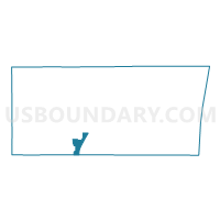
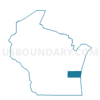
HOLLAND - T 2 Voting District, Sheboygan County, Wisconsin
About
Outline

Summary
| Unique Area Identifier | 697105 |
| Name | HOLLAND - T 2 Voting District |
| County | Sheboygan County |
| State | Wisconsin |
| Area (square miles) | 9.26 |
| Land Area (square miles) | 9.24 |
| Water Area (square miles) | 0.02 |
| % of Land Area | 99.79 |
| % of Water Area | 0.21 |
| Latitude of the Internal Point | 43.59005560 |
| Longtitude of the Internal Point | -87.79073310 |
Maps

Graphs
Select a template below for downloading or customizing gragh for HOLLAND - T 2 Voting District, Sheboygan County, Wisconsin


Neighbors
Neighoring Voting District (by Name) Neighboring Voting District on the Map
- Adell - V 9999 Voting District, Sheboygan County, WI
- BELGIUM - T 1 Voting District, Ozaukee County, WI
- BELGIUM - T 9999 Voting District, Ozaukee County, WI
- Cedar Grove - V 1 Voting District, Sheboygan County, WI
- Cedar Grove - V 2 Voting District, Sheboygan County, WI
- HOLLAND - T 1 Voting District, Sheboygan County, WI
- HOLLAND - T 3 Voting District, Sheboygan County, WI
- HOLLAND - T 4 Voting District, Sheboygan County, WI
- Oostburg - V 3 Voting District, Sheboygan County, WI
- Oostburg - V 4 Voting District, Sheboygan County, WI
- WILSON - T 1 Voting District, Sheboygan County, WI
- WILSON - T 2 Voting District, Sheboygan County, WI
Top 10 Neighboring County Subdivision (by Population) Neighboring County Subdivision on the Map
- Wilson town, Sheboygan County, WI (3,330)
- Oostburg village, Sheboygan County, WI (2,887)
- Holland town, Sheboygan County, WI (2,239)
- Cedar Grove village, Sheboygan County, WI (2,113)
- Belgium town, Ozaukee County, WI (1,415)
- County subdivisions not defined, Sheboygan County, WI (0)
Top 10 Neighboring Place (by Population) Neighboring Place on the Map
Top 10 Neighboring Unified School District (by Population) Neighboring Unified School District on the Map
- Oostburg School District, WI (6,059)
- Cedar Grove-Belgium Area School District, WI (5,873)
- School District Not Defined (Water), WI (0)
Top 10 Neighboring State Legislative District Lower Chamber (by Population) Neighboring State Legislative District Lower Chamber on the Map
Top 10 Neighboring State Legislative District Upper Chamber (by Population) Neighboring State Legislative District Upper Chamber on the Map
Top 10 Neighboring 111th Congressional District (by Population) Neighboring 111th Congressional District on the Map
Top 10 Neighboring Census Tract (by Population) Neighboring Census Tract on the Map
- Census Tract 113, Sheboygan County, WI (7,121)
- Census Tract 6101.02, Ozaukee County, WI (3,660)
- Census Tract 108, Sheboygan County, WI (3,507)